

The observatory that recorded Mount Everest in the record books is now in ruins. india news
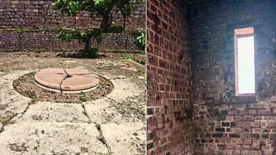
Sironj: “brown” for fair-skinned foreigners. “Zucchini” for restless movements. British surveyors mapped a continent from this range. From here came the numbers measuring the world’s highest mountain. mount everest It was recorded in history but the brown zucchini slipped from it. The name remained and the science faded. Today thieves measure stones here.Located on a windswept hill in Kalyanpur village near Sironj in central Madhya Pradesh, about 100 km north-east of Bhopal in Vidisha district, Brown Tori once beat like the geographical heart of undivided India. From this rocky outcrop, British surveyors determined coordinates, tracked stars and pieced together one of the most daring scientific enterprises in history: the Great Trigonometrical Survey (GTS).Today, the stones have been loosened. The walls are stained. The pendulums have disappeared. The black stone observatories are ruined under the open sky, where astronomers once mapped a continent and made calculations involving measuring the height of Mount Everest. History lives on in fragments here.Records of the Survey of India show that the then Surveyor General, Colonel George Everest, adopted the trigonometric station of Kalyanpur in 1840 as the “core of calculations” for the GTS – a massive 19th-century project that mapped areas spanning present-day India, Pakistan, Bangladesh, Afghanistan, Myanmar and Sri Lanka with mathematical precision that was unprecedented for its era.Long before satellites and GPS, surveyors made series of triangulations in forests, deserts, and mountains. A measured baseline, paired with angles and trigonometry, unlocks distances of thousands of kilometers. Started by William Lambton in the early 1800s and later expanded by Everest, Andrew Scott Waugh and James Walker, GTS transformed cartography and geodesy. Mathematician Radhanath Sikdar later calculated the height of Mount Everest in the 1850s using survey data generated through this massive scientific grid.The brown zucchini sat near its intellectual center of gravity.Historical accounts describe that about 700 workers camped on the hill for about two years with four elephants, 42 camels and 30 horses, while the observatory structures were built of black stones. The yellow color and fiery activity of British officers inspired the name brown zucchini.“This is our hidden hero, who has been completely ignored,” said Shaoub Ghazi, a local history buff who has been promoting the site through social media. He said Everest chose Kalyanpur because it was at a strategic midpoint between Great Arc measurements and Prime Meridian calculations. “It was placed in exactly the right place to split the longitudinal difference between the Great Arc and the Prime Meridian,” he said.
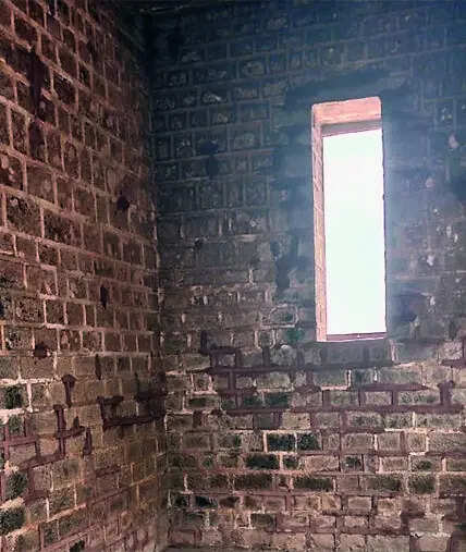
The structure still gives hints of the scientific choreography that was once performed here. The roofless black stone circle has recesses in the north-south walls designed for astronomical observations. The open sky served as the roof of the laboratory. Gas lanterns pointed to telescopes mounted on poles in the nearby village of Surantal for triangulation.Two pendulum-driven structures were later added nearby. Now only hollow shells remain.The pages of the 1917 volume Triangulation in India and Adjacent Countries place Bhuri Tori within the broader geodetic framework underpinning surveys throughout South Asia. Coordinates determined from this mountain range rippled outward through maps, military charts, and administrative boundaries for decades.Now, entropy has taken over. Fragments of masonry have gone missing. The weather gnaws away at the exposed stone. Heritage watchers say vandalism and theft have eroded the site faster than officials admit.Sironj is located at a distance of about two hours by road from Bhopal. Yet the brown gourd is largely absent from tourism circuits and conservation plans. Sironj chief municipal officer Ramprakash said the matter was outside the urban body’s jurisdiction as the site fell under gram panchayat limits.The silence at the hilltop weighs more heavily than the bureaucracy below. When asked about the conservation efforts, Vidisha Collector Anshul Gupta said, “Since it is an archaeological matter, only the agencies concerned can answer it.” As India moves deeper into the age of satellites and remote sensing, the brown zucchini poses a stubborn question: Can a nation preserve the landmarks that first taught it to measure itself?